|
–Geoff-Hart.com: Editing, Writing, and Translation —Home —Services —Books —Articles —Resources —Fiction —Contact me —Français |
by Geoff Hart
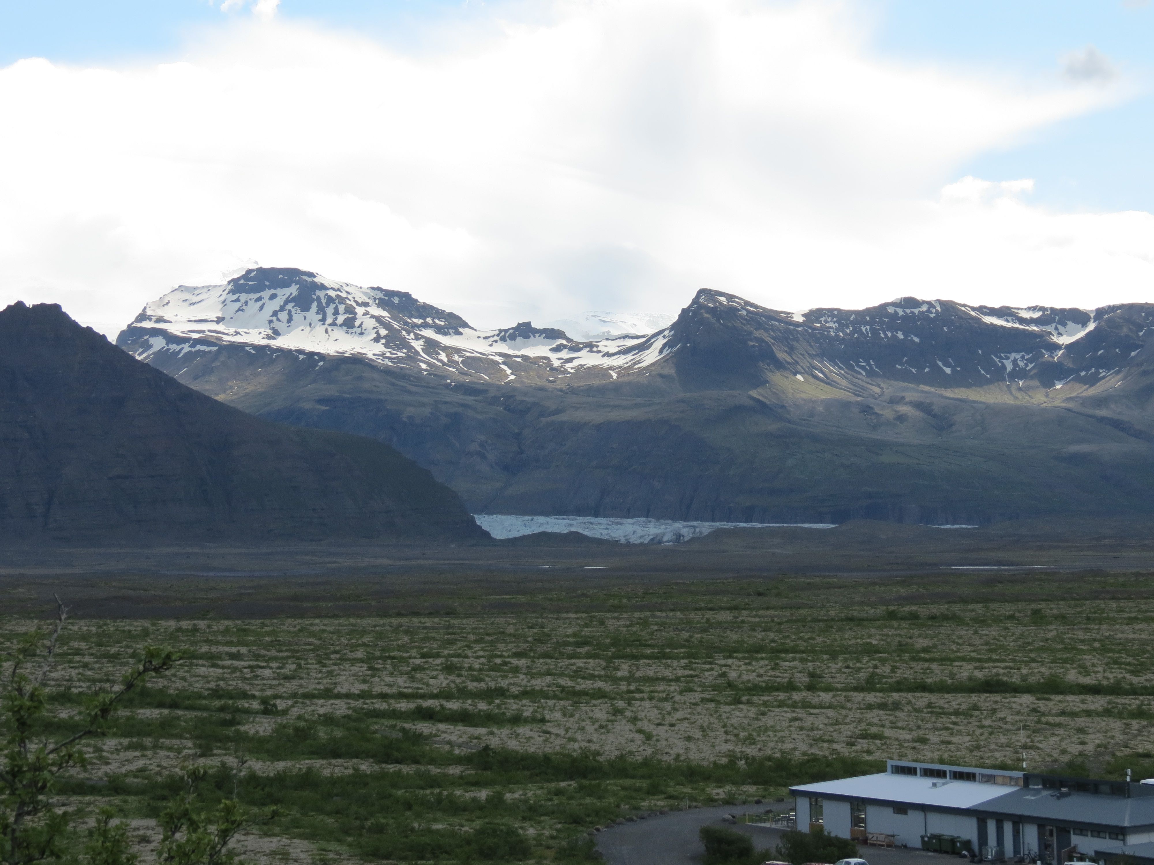
Today was our free day, when Dick turned us loose to explore Skaftafell National Park. Skaftafell is a mountain that plays host to Skaftafellsjökull, one of the many glaciers that decends from the Vatnajökull ice cap, which is the largest ice cap in Iceland (it dominates the south of any map) and the largest ice cap in Europe. Based on the park map and the highly precise measurement technique know as “measuring distances using multiples of one’s finger length”, Skaftafellsjökull descends almost 15 km (about 9 miles) from Vatnajökull into the outwash plains it has created below, reaching a width of about 2 km (1.2 miles) where it spills out of its valley. It lies between the peaks of Hafrafell in the east and Flár in the west. Here's the glacier from near the visitor's center:
A brief digression on Icelandic terminology: a “fell” is a mountain, and a “jökull” is a glacier or ice cap. Many of the following names combine the mountain’s name with the words for mountain, glacier, or both. You can figure out what each name means by simply splitting the word into its component parts. Except, of course, when you can’t. For example, some mountains seem to dispense with the “fell” part. Icelandic, like most other languages, is evolved rather than designed, and thus it isn’t always consistent.
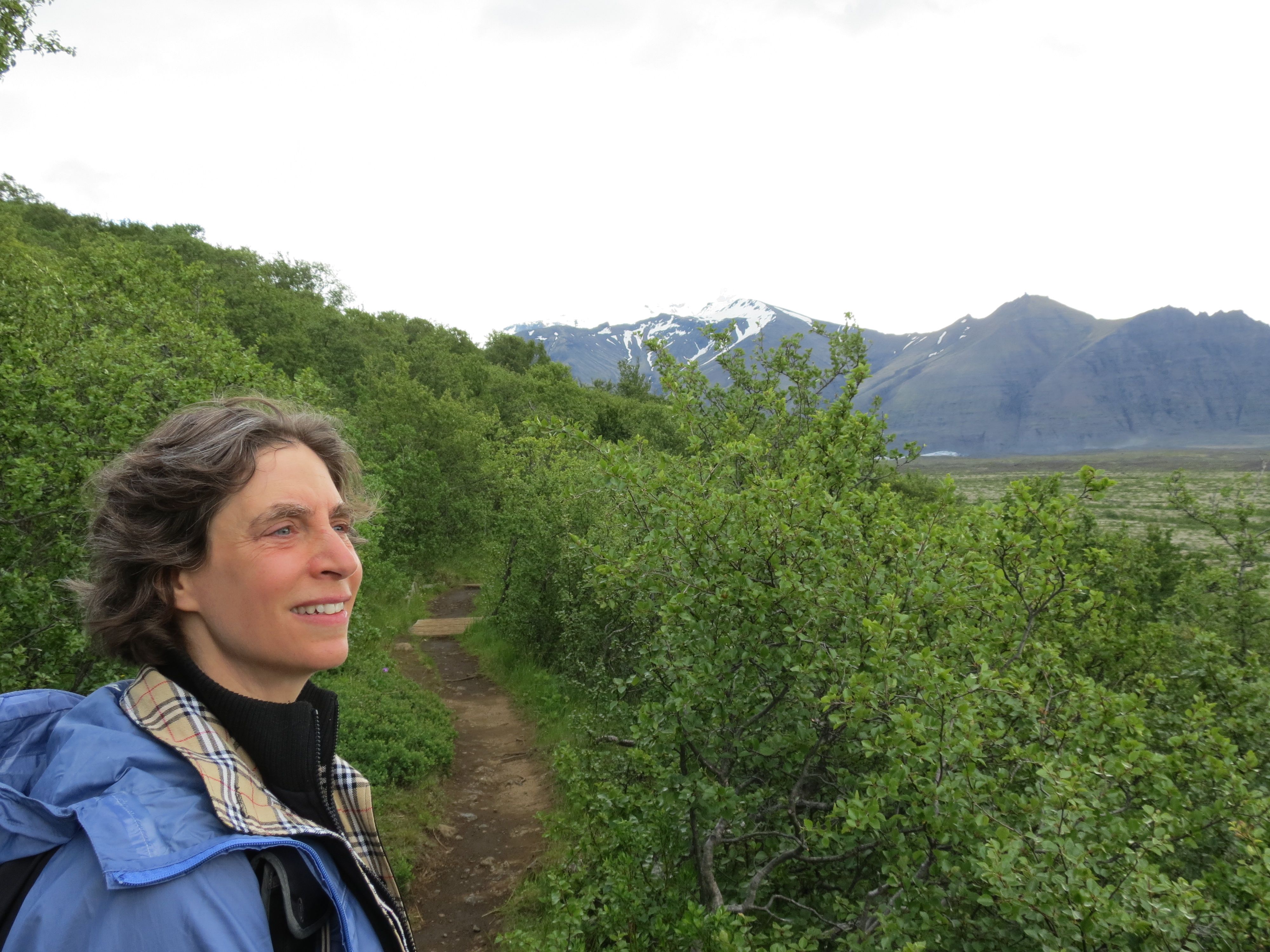
We’d planned our main hike be along the Sjónarnípa path, which is the hardest of the paths we felt comfortable attempting in the time available to us; there’s a harder hike that would take ca. 6 hours, and would have taken us over a high and exposed peak, which would have made it dangerous given the questionable weather. Our thought was that we should start with the hardest hike first, then work our way downhill once we’d exhausted ourselves early in the day, and finish off with the easiest hike to loosen our muscles. The Sjónarnípa path runs up and over Skaftafellsheithi, a sloping heathland that lies below the peak of Flár (at 929 m = about 2900 feet) and which separates Skaftafellsjökull from the Morsárdalur valley to the west. Morsárdalur is home to Morsarjökull, a baby glacier by Icelandic standards, as it’s only about 1 km wide and 2 or 3 km long. Here's Shoshanna, partway up the Sjónarnípa path.
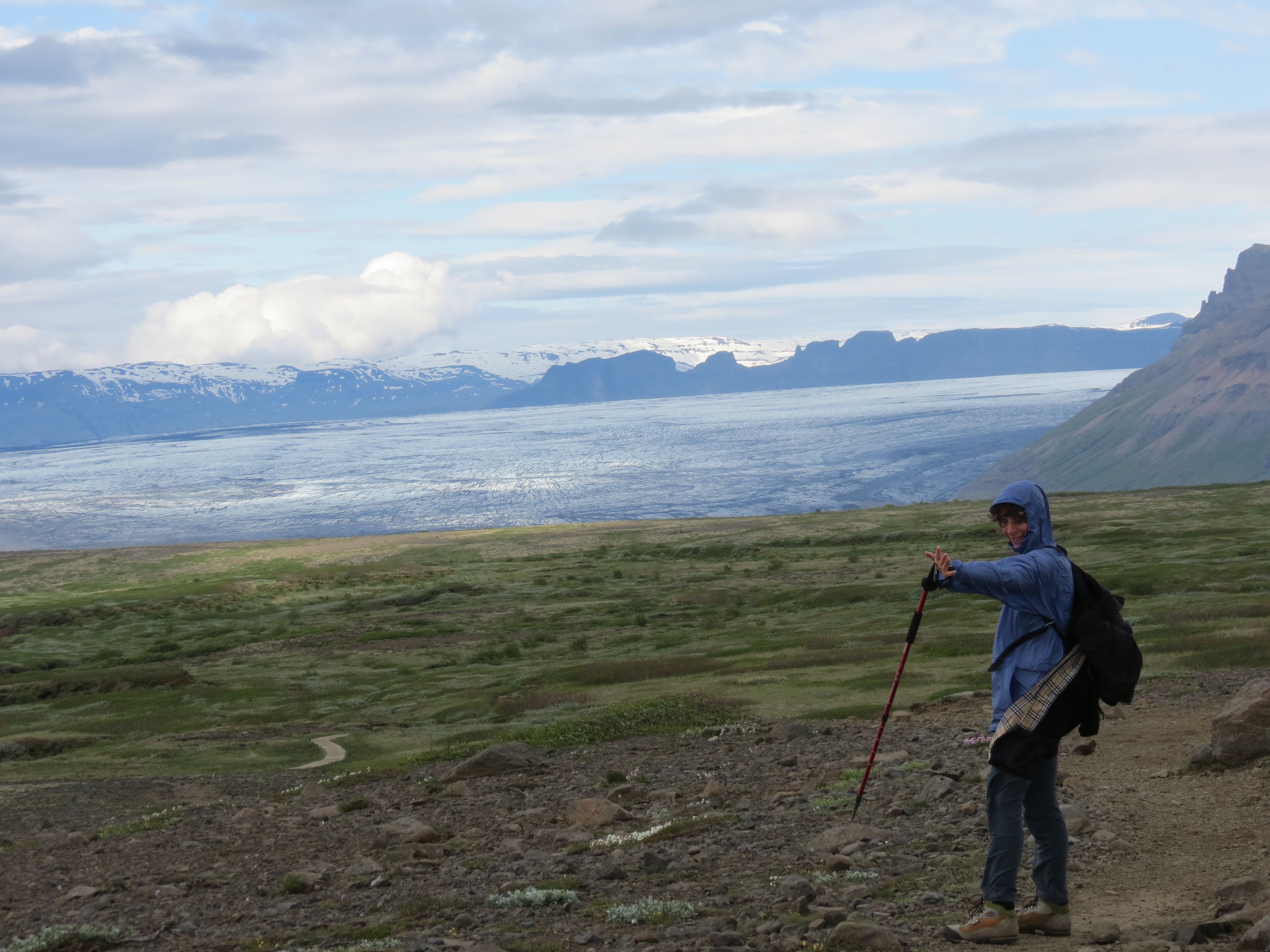
Morsárdalur, in turn, lies just east of the Skaftafellsfjöll mountains, which rise to more than 1100 m (3600 feet) and form the northern border of the Skeitharárjokull glacier, which frankly blows my mind: it descends more than 15 km (9 miles) from the ice cap and stretches more than 10 km (6 miles) wide. We can see if from our hotel, and it spans something like 1/3 of the horizon. (No finger measurements here; this is was we call a “scientific wild ass guesstimate”. Take-home message: I didn’t try to measure it, but it’s huge. And it’s only a smallish part of the overall ice cap.) Here's a look at just the right side of the Skeitharárjokull glacier from the heath, with Shoshanna using her hiking pole as a wind gauge:
The lower slopes of Skaftafellsheithi are covered with surprisingly dense forest composed of dwarf birch trees. These rise up to about 15 feet, and as you get higher and the wind intensifies, the height rapidly dwindles (as shown above). By the top of the hike, the birch are barely ankle height in most places. This is because the wind flowing down the valleys knocks down or tears off anything taller. The dominant vegetation seems to be dwarf junipers and willows, what appears to be something like a dwarf blueberry, and lots of tiny flowers. I tried taking a few photographs of the flowers, but the clouds blocked too much of the light to let me capture images of flowers that were vibrating so hard due to the wind that you could barely inspect them even with your eyes. I described this hike to other group members as “breathtaking”, both because of the amazing glacier views and because the wind became so strong it nearly ripped the breath from one’s lungs; at one point, it knocked Shoshanna off her feet. Fortunately, it mostly blew from the valley onto the heath; had it been blowing towards the cliff faces, we probably would have had to cancel this particular hike.
There were a few birds, mostly small things that only a birder would recognize at a distance and I certainly didn’t, but we did see a whimbrel (curlew), a pretty brown and white bird with a long curved beak, and a pair of skuas, soaring effortlessly on the strong wind. The last part of the descent before we left the Sjónarnípa path was through an extensive alpine wetland, which was protected by a boardwalk. We didn’t meet many hikers until right at the end, as we’d done the loop backwards from how most people did it. Our sore muscles appreciated this approach.
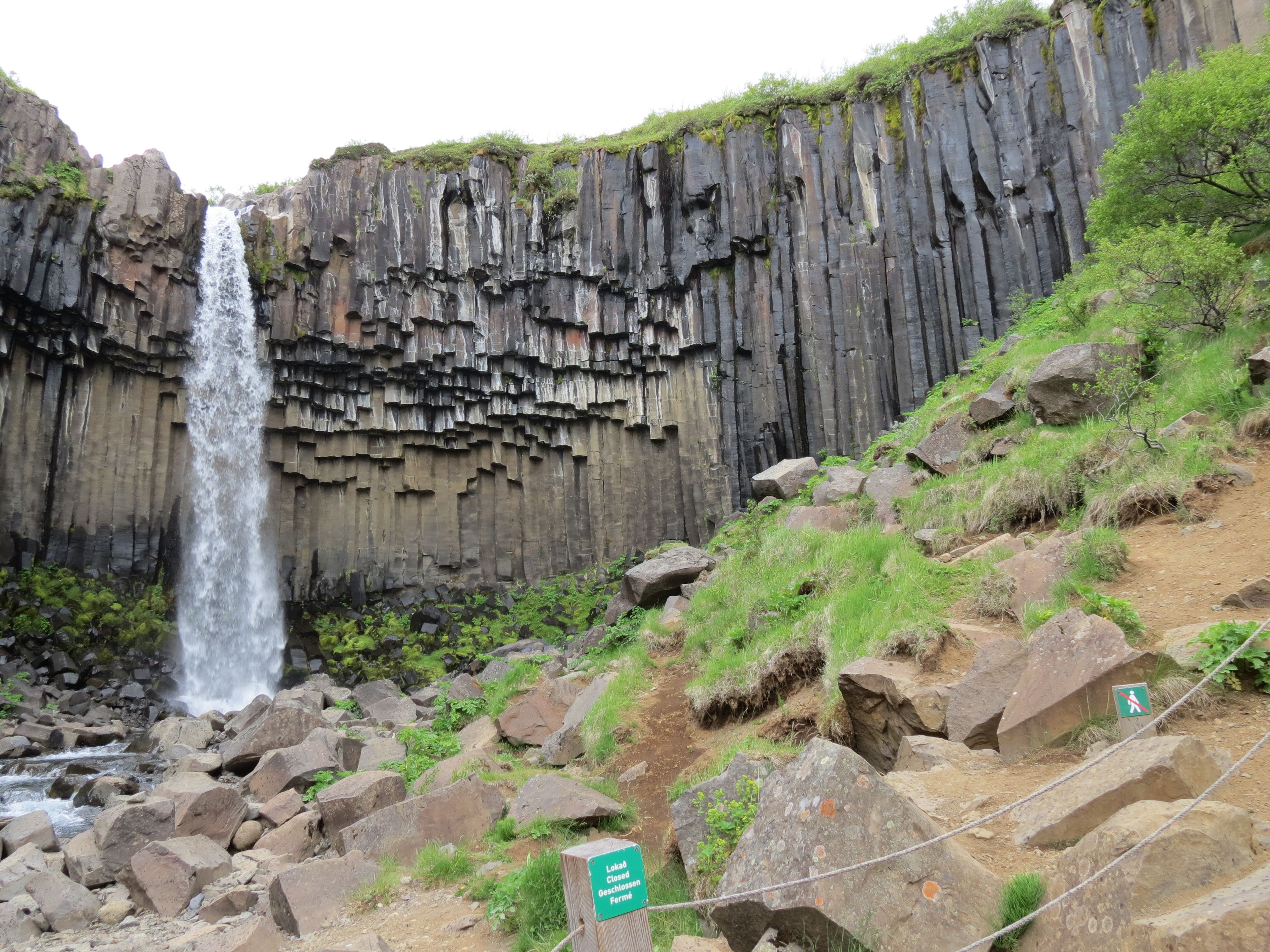
On the downslope, we branched off to see Svartfoss (“the black waterfall”), which is “only” about 70 feet high and has much less flow than some of the grander waterfalls we’d visited in previous days. However, it’s remarkable for having distinctive hexagonal basalt columns running up the walls below the waterfall. (When basalt cools, it tends to form hexagonal structures, which are most famous from the form they take at the Giant’s Causeway in Ireland.) It’s quite striking. Here's how striking:
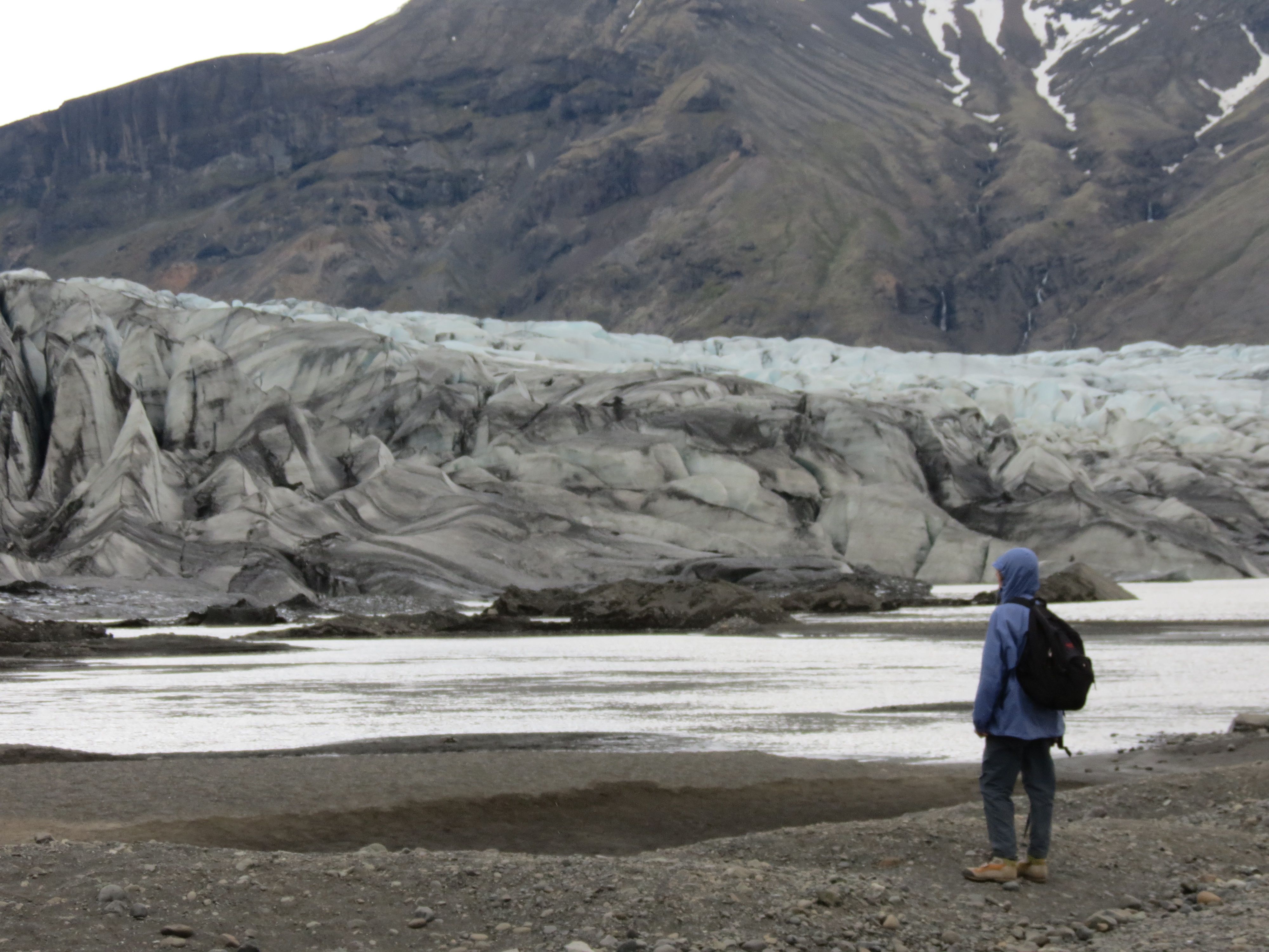
From Svartfoss, we descended to the visitor’s center, where we had lunch. I had a sausage sandwich, which was surprisingly good for national park/visitor center food, and Shoshanna had coconut skir (the Icelandic pudding-texture yogurt), and we swapped bites. We shared a Vatnajökull beer, which was every bit as good as the first time, and a “kleina” (a twisted unfrosted donut that’s an Icelandic favorite) that was bordering on stale, thus not very good. Then we hiked for 45 minutes to the foot of Skaftafellsjökull glacier to get a look at the fractured ice and the lagoon at its base. Here's a look at the glacier's bottom end:
(That shot was taken from a fair distance away, so probably 20+ feet tall in most places.) Pretty and impressive, but the wind was still blowing stink in our faces, occasionally stopping us in our tracks. In addition, it started raining, and we didn’t have much time left before our bus would leave, so we walked back quickly to the visitor center. We got back with enough time to see a nicely done 15-minute film on the park and a recent eruption before crawling wearily to the bus and collapsing.
After a desperately needed shower, I joined Shoshanna and the gang upstairs for a drink before dinner. This time we had Brennivin, the Icelandic akvavit. This used to be illegal in Iceland (along with other alcohol), so until relatively recently, it was sold only on the black market and had a simple black and white label, which it retains to this day. It was good enough that we’re planning to bring a bottle home in our checked bags. We hopped across the street to the truck stop, where we had pizza for dinner. Shoshanna’s was most interesting, as it was topped with salmon and leeks.
Finally, off to the hotel to wind down, since we have an early start tomorrow, when we do the long drive to return to Reykjavic. After more than 5 hours of hiking, the first three-quarters of which were on steep slopes, my muscles have that pleasant burn of fatigue that tells me I’ll be stiff and sore tomorrow.
Next installment: July 6: Travel back to Reykjavic
©2004–2024 Geoffrey Hart. All rights reserved.